
W. G. Atkinson Map of the Battlefield
8 11 2022Comments : Leave a Comment »
Tags: Maps of Bull Run, Resources
Categories : Maps of Bull Run, Resources
Map of 4th Alabama Fight on Matthews Hill
5 11 2022Map of the fighting on Matthews Hill and the 4th Alabama Infantry’s fight on it, by Capt. Porter King, Co. G, 4th Alabama Infantry.

Contributed by John Hennessy
Comments : 2 Comments »
Tags: 4th Alabama, Maps of Bull Run, Resources
Categories : Maps of Bull Run, Resources
6th North Carolina Ravine
4 10 2020From August 11 to August 27 this year I posted several letters from members of the 6th North Carolina Infantry describing the regiment’s actions, and specifically their approach to the battlefield. As I was transcribing them, I sent a note to Friend of Bull Runnings (FOBR, a truly worthless title I bestow on folks who have been helpful to the site but, hey, it’s a title nonetheless) John Hennessy:
Working my way through some 6th NC stuff, and for not the first time I’m running across references to the regiment emerging from a “rugged ravine” to come upon Sherman’s (Ricketts’s) battery.
Any idea what ravine they’re talking about?
His response:
The ravine–yes. Just S-SE of Griffin’s guns is a ravine at least some of the 6th used, though it’s only “rugged” on a relative basis. A Pittsburgher wouldn’t even notice it. But on that field, it’s fairly apparent if you walk the ground, which is today pretty well choked with trees. You can see it well on Google Earth, connecting the park and the community college. It points straight toward Griffin’s guns.
Of course, the 6th probably had a front a couple-hundred yards long. The ravine is short and narrow, and so probably most men never saw it. Of course if you look at Google Earth, you can see there is a pretty steep rise to the right of the ravine which those of the 6th not in the ravine would have encountered as they moved forward.
John obligingly provided this map (click it to enlarge):

Comments : Leave a Comment »
Tags: 6th North Carolina, Articles, John Hennessy, Manassas National Battlefield Park, Maps
Categories : Articles, Maps of Bull Run, The Battlefield
Map: From Surveys by an Officer of Beauregard’s Staff
20 03 2020I came across an original lithograph of this post-war map last week in a shop in Gettysburg. You can find it online, with more info, here. It’s interesting in both what it includes, and what it does not.
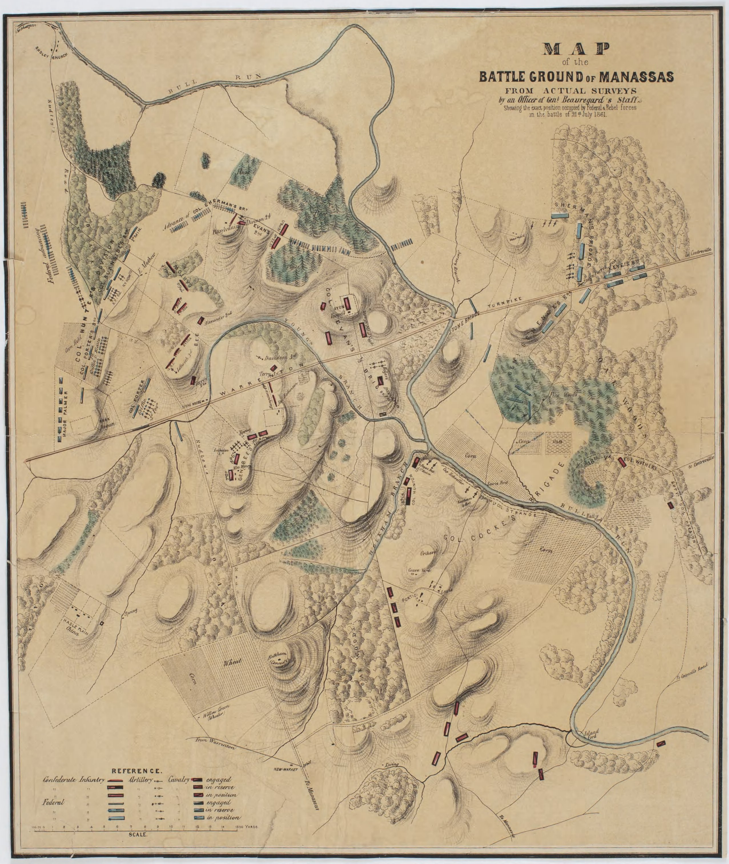
Comments : 3 Comments »
Tags: Maps of Bull Run, Resources
Categories : Maps of Bull Run, Resources
A New Old Map of the Battlefield
21 09 2016Author John Hennessy passed along this heretofore unseen, by him or me, map. It was provided to him by reader Kimball Brace, who found it in the Library of Virginia. Kim has been researching E. Porter Alexander and the signal stations around Manassas and the Bull Run Line.
Mr. Hennessy correctly points out some of the notable features of the map include its depictions of the Beale and Van Pelt houses and details of the topography around the Stone Bridge.
The key (click for large images):

The map (click for large images):

Here is a transcription of the key, provided by a staff member at the Winery at Bull Run. I’ll try to find out more about that part of the story later…
The key:
A. Centreville Road to Stone Bridge
B. Forest each side Centreville Road
C. Enemies long Parrot Gun, Rifled; opening light Sunday Morning July 21st 1861, on Col Wheat’s Battalion (marked by a circle with an X in it)
D. Beale’s House, vacated by family Wednesday July 17th.
E. Shaeffers encampment, of Battalion, Co S Beauregard Rifles, Capt Shaeffer. New Orleans ____ Blues. Capt Goodauyn. New Market ___ Capt H N B Wood.
F. Thicket to which a large force of the enemy were concealed.
G. Cornfield fronting entrenchment Schaeffer’s Battalion
H. Entrenchment left-wing Capt Wood’s __ north side Bull Run.
I. Shaeffer’s Battalion entrenched, s.side Bull Run.
J. Latham’s Battery 2 guns (one marked XX) firing upon enemy at A B & C
K. Albemarle Regt Col Strange Comm at, entrenched on Bluff of Bull Run
L. Wheat Stubble between Albemarle Regt. And front of Enemy advancing at this point, Capt Latham’s Artillery, opening upon them, they commenced the flank to O, all around
M. Stone Bridge
N. Battery, of Enemy (not known invisible) moved with infancy upon Left-Flank of S.C. Army.
O. Advance of enemy, from A,B, (Carrying C.) F & G to O. and direction up to V.
P. Cornfield of Beale’s
Q. Forest Felled by Shaeffer’s Battalion
R. Turnpike to Warrenton from Stone Bridge
S. Bull Run
T. Vanpelt’s House, He having 2 sons in the Northern Army
U. Open fields over which reinforcements passed. Met the enemy, and the result was as the country knows
V. Headquarter’s, Gen E Coucke Lewis House
W. 1 Gun from Latham’s Battery managed by Lieut Saunders New O ____ Blues.
a. *Cannon Shot from enemy into headquarters
b. XX Guns’ supported by Charlottsville
c. X Monticello Guards of Latham’s Battery
d. Cursive X : open fields leading to Manassas from Lewis Farm
X. Circle around an x: Col Wheat’s encampment before 21st July
Comments : 8 Comments »
Tags: Articles, Beale House, Library of Virginia, Maps of Bull Run, Van Pelt House
Categories : Articles, Maps of Bull Run, The Battlefield
Tour Update 4/10/2016 – NEW MAPS!!!
10 04 2016
A Harper’s Weekly Map That Will Surely Make You Go “Hmmm…”
Hello all you attendees! Our featured guide for the tour (13 days away!), John Hennessy, has forwarded applicable maps from his new edition of An End to Innocence. These are the maps you should bring with you, as opposed to those I posted here on Friday. Of course, one can never have too many maps in general, but what with all the walking we’ll be doing I would think you’d want to carry as little as possible.
Click on the link below and print or store these maps as you did the others, and if you have time compare them two sets. There are subtle and not-so-subtle differences, and in a way you can trace how Hennessy’s thinking on the battle has evolved over the decades. They may look a little out of proportion in your browser, but will print OK.
Comments : 4 Comments »
Tags: Articles, Field Trips, Manassas National Battlefield Park
Categories : Articles, Field Trips, Maps of Bull Run
Sgt. William P. Holden, Co. H, 2nd Maine Infantry, On the Battle
29 01 2013Position of the Second.
1861 8-3 Bangor Daily Whig and Courier 2d Maine Bull Run with map 
We copy above what we should judge to be a very correct diagram of the position of our Second at the battle of Bull Run. It was roughly made, with such conveniences as are at the command of soldiers, by Wm. P. Holden of this city, and accompanied a private letter to his father. We copy such portions of the letter as explain the map; that our readers may understand, as clearly as may be, the exact position of our regiment, at the fight. After giving an account of the terrible forced march, fatigue and almost starvation preceding the attack, he says: –
We started for Bull Run on Sunday morning at 2 o’clock. The head of the column came up to a battery about 8 o’clock, and the artillery commenced throwing shell and balls into it, and in about half an hour they left it, and retreated to another. The artillery moved to the top of a hill, marked our battery. I have only marked on the map the battery which our regiment charged upon. There were eight more to the right. It was 12 o’clock before our regiment was called to charge. They were about three miles to the rear of the battery which they charged upon. They marched double quick all the way, and as it was a very hot day, you can judge what kind of shape the boys were in to fight. A great many of them could not stand it to run so far, and fell out of the ranks before they arrived at the battle ground. Our regiment went upon the main road as far as the line, marked through the cornfield and woods, and drew up in line of battle, in front of the woods. When we came out of the woods, there were a lot of rebel troops in the orchard, but as they were dressed in gray, our officers supposed they were our troops, and did not find out otherwise until they retreated some distance, turned and fired upon us, killing all that were killed during the fight. The Colonel then gave the order to charge upon them, which we did until within 40 yards of the battery, where our men stood until they were ordered to retreat by Col. Keyes. They then retreated to the woods, and laid down to rest. Gen. Tyler soon came down and ordered them to charge again, but Colonel Keyes said our regiment had done their share of fighting, and that he had better order one of the Connecticut regiments on, as they had not done any fighting. About 4 o’clock a general order to retreat to Centreville was given, as the rebels had received a reinforcement of 30,000 men from Manassas, and our troops had been fighting for eight hours and were pretty well tire out. We retreated to Centreville and encamped. About 12 o’clock at night, orders came from Gen. McDowell to retreat to Washington.
Bangor Daily Whig and Courier, 8/3/1861
William P. Holden at Ancestry.com
Contributed by John Hennessy
Comments : Leave a Comment »
Tags: 2nd Maine, Maps of Bull Run, Resources, Soldier Letters
Categories : Maps of Bull Run, Private Correspondence, Resources
Preview: “The Battle of First Bull Run”
9 01 2012
A few weeks ago I received a copy of Blaikie Hines’s The Battle of First Bull Run Manassas Campaign – July 16-22, 1861: An Illustrated Atlas and Battlefield Guide. Anything with a title like that deserves some attention from a blog with a name like this one’s, and I plan on going into deeper detail with an author interview in the future, but I just wanted to get the word out. This is a pretty nice book, even if it does have several elements that are eerily similar to something I’ve been working on myself. No, I’m not accusing anyone of espionage, and really it’s only one of many elements in this book and on a much smaller scale than what I’m thinking about. Mr. Hines gave Bull Runnings a very nice acknowledgement (no, I did not see or even hear of this one until it was finished), but I’ll use that to point out a problem with the book: the web address in the acknowledgement is wrong. He left out the “.wordpress” part of it. No, I’m not whining, but here’s why I bring it up: this book is self-published. There’s nothing wrong with that in and of itself, but a problem often seen in self-published works is weak editing. The narrative here does suffer from typos and grammatical errors that drive a Chicago Manual of Style toting geek like me to distraction. Call me pedantic, call me what you will. I’m not going to dwell on the mistakes of grammar, punctuation, or fact at this point.
OK, now that we have that out of the way, let me briefly describe this oversized, landscape oriented book. It’s paperback, and the pages are a glossy, heavy stock. That’s good for taking out onto the field, and that’s where it’s meant to be taken. The layout is a little unconventional, but Hines has touched all the bases, giving an overview of events leading up to the battle, descriptions of the players, plenty of photographs (many labeled with landmarks), various maps including some utilizing satellite imagery, orders of battle, then and now photos, narrative vignettes, descriptions of arms, equipment, and uniforms, I can go on. At first glance, here’s what I think: if you have a particular interest in First Bull Run, you really should get your hands on a copy, if you can afford it. Stay tuned here for more.
Comments : 3 Comments »
Tags: ACW Books, Articles, Blaikie Hines
Categories : Articles, Books, bull run, Maps of Bull Run, The Battle, The Battlefield
Cool Bull Run Stuff on the Web
17 06 2011A few links I ran across thanks to Facebook friends and others:
Go here for an overview of the battle and a cool animated map courtesy of The Civil War Trust.
Also from The Civil War Trust, John Hennessy talks about Jackson at Bull Run here. For more, see John’s article on the topic here.
And read this interesting bit on Matthew Brady at Bull Run from The Atlantic here.
Comments : Leave a Comment »
Tags: Articles, Civil War Trust, Digital History
Categories : Articles, Civil War On the Web, Digital History, Maps of Bull Run
D. B. Harris Map
10 11 2010Here’s an unpublished map of the First Bull Run battlefield, by Confederate engineer D. B. Harris. According to the notation, this sketch was used by Beauregard to prepare his map of the battlefield. It’s a recent acquisition of the Manassas National Battlefield Park and has been provided by Ranger Jim Burgess. You’ll need to use your photo viewer’s zoom to see the detail. I’ve viewed the original and it’s quite faded. It’s difficult to tell exactly what is being depicted here – for instance, is this as of a point in time or does it show movement? Look at all the guns shown north of the Warrenton Pike, for instance. Click once for a larger image. Click that image for a really large image.

By sketch I mean this was made on the field and was not a final product. As noted on the map, it was surveyed, so it is more than a free-hand sketch. FYI, Confederate items are in blue.
Comments : 6 Comments »
Tags: Articles, Maps of Bull Run
Categories : Articles, Maps of Bull Run, The Battle, The Battlefield


Recent Comments