I apologize for not having upheld my promise of Friday photo postings. Life has a nasty habit of getting in the way. Let’s just say it’s been a very busy year for me in lots of ways, with no signs of letting up any time soon.
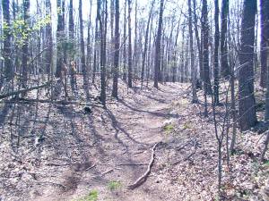
Here’s a shot of one of my very favorite spots on the Bull Run battlefield. This is about all that’s left of the original Sudley Road.
Part of the road generally formed the western border of the Henry Hill fighting, though technically I think the hill continues west past the road before the land rolls into Chinn Ridge, the scene of Howard’s undoing. Also known as the Manassas-Sudley Rd., the Sudley & New Market Rd, and even simply the Manassas Rd, this tract led from the crossings of Bull Run at Sudley Ford and then Catharpin Run at Sudley Mineral Springs, through the intersection at the Stone House on the Warrenton Pike, all the way to Manassas Junction. Two divisions of McDowell’s army, first Hunter’s and then Heintzelman’s, followed this general route south toward Henry Hill.
How to get there
If you park at the main Visitor’s Center, walk back down the driveway (west) toward Sudley Rd. At the road, turn left (south) into the grass (you know, you are permitted to leave the beaten path at the park!) and head toward the woods. There you’ll find the original trace separated from the modern road by a thin screen of trees. It’s only maybe 100 yards long, but this will give you a better idea of what constituted a road in 1861.


Been there dozens of times and didn’t know it was there. Checked it out this weekend. Keep the photos coming…
LikeLike
There are other stretches of the road in the park that one can follow. The road actually winds around modern Sudley Road. You can follow it just south of the pictured track but it is on the west side of the modern road. It can be located by the telephone poles. As of a few years ago, it was still part of the VDOT right away. I believe I have a found a couple of similar traces north of the Warrenton Turnpike intersection out toward Sudley Church and the unfinished railroad as well. Manassas Battlefield is a gem. I have lived within a few miles of it for nearly twenty years and have spent uncountable hours trapsing over it. I have written a book on Longstreet’s attack with a raving introduction by John Hennessy. I had also undertaken a major research project on the RR Cut action of August 29 but after my failure to get the first work published with John’s backing, I gave it up. Unfortunately, publishers don’t want anything to do with Second Manassas as it apparently does not draw.
LikeLike
Thanks for the info, Scott. I’ll hunt up the locations north of the intersection at some point. I was aware of the existence of a trace on the west side south of the one I pictured, but needed your reference to the telephone poles to jar my memory. IIRC, the character of the trace in that spot is not too photogenic.
I envy your living so close to the park. And it’s too bad about the market for BR2 books. But you could always do a web project…
LikeLike